
The Chapada Diamantina National Park (Parque Nacional da Chapada Diamantina in Portuguese) is in the Chapada Diamantina region of Bahia state in the Northeast of Brazil. The park is approximately 400 kilometres inland from Salvador, the capital city of Bahia.
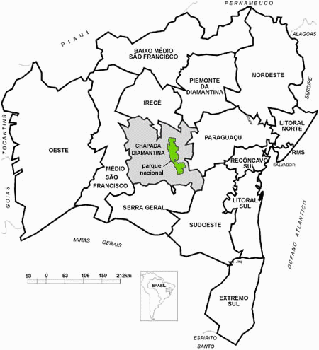
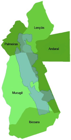
Chapada Diamantina has an area of 38,000 km². To compare, it’s bigger than Netherlands (37,000 km²), Belgium (33,000 km²), Albania (29,000 km²), Haiti (28,000 km²), and the U.S. state of Maryland (32,000 km²). The national park inside this region comprises 1,520 km² and is located in a place known as Serra do Sincorá. Here can you see the cities that surround the national park:
Chapada is a Brazilian word that means a region of steep cliffs, usually at the edge of a plateau. Diamantina refers to the diamonds found there in the mid 1800s. Both gold and diamonds have been found there.
The park was created in the 1980s in response to growing ecotourism.
The region is semi-arid, however it has no shortage of water, from the many rivers and streams. On average, the altitude of the park is between 800 and 1000 metres above sea level, although parts are as high as 2000 metres above. Near the park is located the highest point of state in Pico do Barbado with 2,036 meters. The park is typified by hills, mountains, valleys and monoliths, with few plains.
Many cave systems were formed by the rivers that run through the region. Several of these rivers run red due to tannin in the water.
The flora and fauna are highly varied. Although there are few large mammals, there is a wide variety of reptiles, amphibians, birds, insects and small mammals. The flora mainly consists of small scrubland bushes, orchids and cactus.